
Ortiga topographic map
Interactive map
Click on the map to display elevation.
About this map
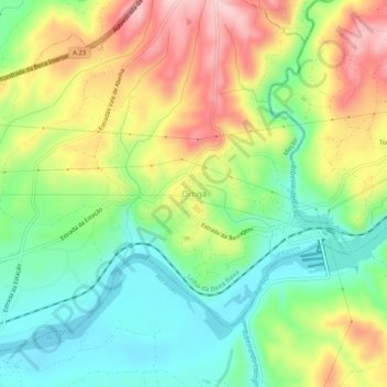
Name: Ortiga topographic map, elevation, terrain.
Location: Ortiga, Mação, Santarém, Portugal (39.46601 -8.03533 39.50601 -7.99533)
Average elevation: 364 ft
Minimum elevation: 75 ft
Maximum elevation: 768 ft
Other topographic maps
Click on a map to view its topography, its elevation and its terrain.
Águas Quentes
Águas Quentes, Mação, Santarém, Portugal
Average elevation: 932 ft
Casal da Barba Pouca
Portugal > Santarém > Mação > Casal da Barba Pouca
Casal da Barba Pouca, Mação, Penhascoso e Aboboreira, Mação, Santarém, 6120-721, Portugal
Average elevation: 771 ft