
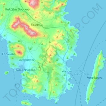
Municipality of Lavreotiki topographic map
Interactive map
Click on the map to display elevation.
About this map
Name: Municipality of Lavreotiki topographic map, elevation, terrain.
Average elevation: 262 ft
Minimum elevation: -20 ft
Maximum elevation: 2,116 ft
Other topographic maps
Click on a map to view its topography, its elevation and its terrain.
Rafina
Greece > Attica > Regional Unit of East Attica > Rafina Municipal Unit
Rafina, Rafina Municipal Unit, Municipality of Rafina - Pikermi, Regional Unit of East Attica, Attica, 190 09, Greece
Average elevation: 144 ft
Astypalaia
Greece > Attica > Regional Unit of East Attica > Anavissos Municipal Unit
Astypalaia, Anavissos Municipal Unit, Municipality of Saronikos, Regional Unit of East Attica, Attica, 190 13, Greece
Average elevation: 33 ft
Ανάβυσσος
Greece > Attica > Regional Unit of East Attica > Anavissos Municipal Unit
Ανάβυσσος, Anavissos Municipal Unit, Municipality of Saronikos, Regional Unit of East Attica, Attica, 190 13, Greece
Average elevation: 299 ft
Koropi
Greece > Attica > Regional Unit of East Attica
Koropi, Municipality of Kropia, Regional Unit of East Attica, Attica, 194 00, Greece
Average elevation: 486 ft
Nea Makri Municipal Unit
Greece > Attica > Regional Unit of East Attica
Nea Makri Municipal Unit, Municipality of Marathonas, Regional Unit of East Attica, Attica, 190 05, Greece
Average elevation: 712 ft
Christoupoli
Greece > Attica > Regional Unit of East Attica > Spata-Loutsa Municipal Unit
Christoupoli, Spata-Loutsa Community, Spata-Loutsa Municipal Unit, Municipality of Spata - Artemida, Regional Unit of East Attica, Attica, 190 04, Greece
Average elevation: 400 ft
Limenas Markopoulou
Greece > Attica > Regional Unit of East Attica
Limenas Markopoulou, Municipality of Markopoulo Mesogaias, Regional Unit of East Attica, Attica, 190 23, Greece
Average elevation: 305 ft
Municipal Unit of Voula
Greece > Attica > Regional Unit of East Attica
Municipal Unit of Voula, Municipality of Vari - Voula - Vouliagmeni, Regional Unit of East Attica, Attica, 166 73, Greece
Average elevation: 187 ft
Glyka Nera Municipal Unit
Greece > Attica > Regional Unit of East Attica
Glyka Nera Municipal Unit, Municipality of Paiania, Regional Unit of East Attica, Attica, 153 54, Greece
Average elevation: 1,014 ft
Artemida
Greece > Attica > Regional Unit of East Attica > Artemida Municipal Unit
Artemida, Artemida Municipal Unit, Municipality of Spata - Artemida, Regional Unit of East Attica, Attica, 190 16, Greece
Average elevation: 125 ft
Gerakas Municipal Unit
Greece > Attica > Regional Unit of East Attica
Gerakas Municipal Unit, Municipality of Pallini, Regional Unit of East Attica, Attica, 153 44, Greece
Average elevation: 850 ft
Vouliagmeni Municipal Unit
Greece > Attica > Regional Unit of East Attica
Vouliagmeni Municipal Unit, Municipality of Vari - Voula - Vouliagmeni, Regional Unit of East Attica, Attica, 166 71, Greece
Average elevation: 66 ft
Pikermi Municipal Unit
Greece > Attica > Regional Unit of East Attica > Pikermi Municipal Unit
Pikermi Municipal Unit, Municipality of Rafina - Pikermi, Regional Unit of East Attica, Attica, Greece
Average elevation: 745 ft
Anavissos Municipal Unit
Greece > Attica > Regional Unit of East Attica
Anavissos Municipal Unit, Municipality of Saronikos, Regional Unit of East Attica, Attica, Greece
Average elevation: 197 ft
Mount Parnitha National Park
Greece > Attica > Regional Unit of East Attica
Mount Parnitha National Park, Regional Unit of East Attica, Attica, Greece
Average elevation: 1,781 ft
Marathon
Greece > Attica > Regional Unit of East Attica
Marathon, Municipality of Marathonas, Regional Unit of East Attica, Attica, 190 07, Greece
Average elevation: 479 ft