
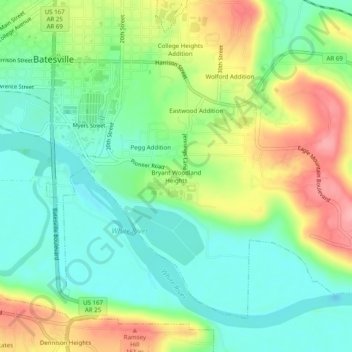
Bryant Woodland Heights topographic map
Interactive map
Click on the map to display elevation.
About this map
Name: Bryant Woodland Heights topographic map, elevation, terrain.
Average elevation: 351 ft
Minimum elevation: 213 ft
Maximum elevation: 577 ft
Other topographic maps
Click on a map to view its topography, its elevation and its terrain.
Wolford Addition
United States > Arkansas > Independence County > Batesville
Wolford Addition, Batesville, Independence County, Arkansas, 72501, United States
Average elevation: 361 ft
Batesville
United States > Arkansas > Independence County > Batesville
Batesville, Independence County, Arkansas, 72501, United States
Average elevation: 358 ft
Quail Valley
United States > Arkansas > Independence County > Batesville > Quail Valley
Quail Valley, Batesville, Independence County, Arkansas, United States
Average elevation: 361 ft