
Make a donation
Gear up for your next adventure:
As an Amazon Associate, this site earns from qualifying purchases at no extra cost to you.
Mucuchíes topographic map
Click on the map to display elevation.
Make a donation
Gear up for your next adventure:
As an Amazon Associate, this site earns from qualifying purchases at no extra cost to you.
Mucuchíes
Mucuchíes is a town in the Rangel Municipality of Mérida State, Venezuela. It is at an altitude of 2,983 meters and has a cool climate, with an average temperature of 11 °C. Patron saint festivities are held during the month of December, with their patron saints St. Lucia and St. Benedict the Moor. The town was founded by Bartolomé Gil Naranjo in 1586.[1]
Make a donation
Gear up for your next adventure:
As an Amazon Associate, this site earns from qualifying purchases at no extra cost to you.
About this map
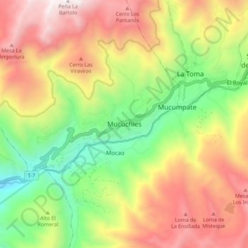
Name: Mucuchíes topographic map, elevation, terrain.
Average elevation: 11,165 ft
Minimum elevation: 8,360 ft
Maximum elevation: 14,265 ft
Make a donation
Gear up for your next adventure:
As an Amazon Associate, this site earns from qualifying purchases at no extra cost to you.