
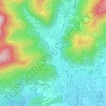
Le Phanitor topographic map
Interactive map
Click on the map to display elevation.
About this map
Name: Le Phanitor topographic map, elevation, terrain.
Average elevation: 1,991 ft
Minimum elevation: 1,490 ft
Maximum elevation: 3,199 ft
Other topographic maps
Click on a map to view its topography, its elevation and its terrain.
Malvaux
France > Bourgogne-Franche-Comté > Territoire-de-Belfort > Lepuix
Malvaux, Lepuix, Belfort, Territoire-de-Belfort, Bourgogne-Franche-Comté, France métropolitaine, 90200, France
Average elevation: 2,507 ft
Foyer communautaire Jean Devillers
France > Bourgogne-Franche-Comté > Territoire-de-Belfort > Lepuix
Foyer communautaire Jean Devillers, D 466, Lepuix, Belfort, Territoire-de-Belfort, Bourgogne-Franche-Comté, France métropolitaine, 90200, France
Average elevation: 3,169 ft