
Caldas de Monchique topographic map
Interactive map
Click on the map to display elevation.
About this map
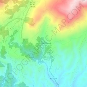
Name: Caldas de Monchique topographic map, elevation, terrain.
Average elevation: 984 ft
Minimum elevation: 285 ft
Maximum elevation: 2,323 ft
Other topographic maps
Click on a map to view its topography, its elevation and its terrain.
Caldas de Monchique
Portugal > Algarve > Caldas de Monchique > Caldas de Monchique
Caldas de Monchique, Monchique, Faro, Algarve, Portugal
Average elevation: 988 ft