Geolocate

Rocklea topographic map

Click on the map to display elevation.

About this map

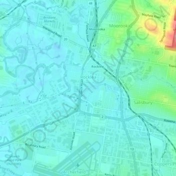
Name: Rocklea topographic map, elevation, terrain.

Location: Rocklea, Brisbane City, Queensland, 4106, Australia (-27.57211 152.98251 -27.52961 153.02477)

Average elevation: 52 ft

Minimum elevation: -7 ft

Maximum elevation: 308 ft

Other topographic maps

Click on a map to view its topography, its elevation and its terrain.

Willmington Park

Australia > Queensland > Brisbane City

Average elevation: 121 ft

Mount Gravatt

Australia > Queensland > Brisbane City

Average elevation: 230 ft

Ithaca

Australia > Queensland > Brisbane City > Ithaca

Average elevation: 102 ft

Gear up for your next adventure:

🦺Reflective Outdoor Gear - Safety gear for low‑light conditions
🎒Day Hiking Backpack - Lightweight backpack perfect for day trips and outdoor adventures
🦶Carbon Trekking Poles - Reduce knee impact on steep descents with ultra-light poles
🔦Compact Flashlight - Reliable flashlight for emergencies
🥾Men's Hiking Boots - Durable, waterproof footwear for rugged terrain and steep inclines

As an Amazon Associate, this site earns from qualifying purchases at no extra cost to you.