
Ciudad Fernández topographic map
Interactive map
Click on the map to display elevation.
About this map
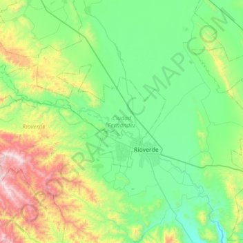
Name: Ciudad Fernández topographic map, elevation, terrain.
Location: Ciudad Fernández, San Luis Potosí, 79650, México (21.85555 -100.50052 22.12685 -99.94829)
Average elevation: 3,953 ft
Minimum elevation: 2,713 ft
Maximum elevation: 8,058 ft
Other topographic maps
Click on a map to view its topography, its elevation and its terrain.
El Refugio
México > San Luis Potosí > Ciudad Fernández > El Refugio
El Refugio, Ciudad Fernández, San Luis Potosí, 79650, México
Average elevation: 3,304 ft
Atotonilco
México > San Luis Potosí > Ciudad Fernández
Atotonilco, Ciudad Fernández, San Luis Potosí, México
Average elevation: 4,442 ft