Geolocate

Province of Pachitea topographic map

Click on the map to display elevation.

About this map

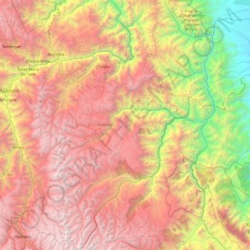
Name: Province of Pachitea topographic map, elevation, terrain.

Location: Province of Pachitea, Huánuco, Peru (-10.48889 -76.13621 -9.61250 -75.59366)

Average elevation: 8,428 ft

Minimum elevation: 1,007 ft

Maximum elevation: 16,385 ft

Other topographic maps

Click on a map to view its topography, its elevation and its terrain.

Churin

Peru > Huánuco > San Francisco de Asís

Average elevation: 12,070 ft

Vichaycoto

Peru > Huánuco > Pillco Marca

Average elevation: 7,162 ft

Tingo María

Peru > Huánuco > Rupa-Rupa > Tingo María

Average elevation: 2,654 ft

Maynas

Peru > Huánuco > Marías

Average elevation: 12,602 ft

Gear up for your next adventure:

🧭Hiking Compass - Precision compass for reliable navigation in the wilderness
📻Weather Alert Radios - Stay informed of storm risks while off-the-grid
🛡️Bear Spray Outdoor - Protection in bear country hikes
🩳Quick‑Dry Hiking Shorts - Comfortable and quick‑dry shorts for summer hiking
📷Action Camera - Capture your outdoor adventures in HD

As an Amazon Associate, this site earns from qualifying purchases at no extra cost to you.