
Make a donation
Gear up for your next adventure:
As an Amazon Associate, this site earns from qualifying purchases at no extra cost to you.
Winterthur topographic map
Click on the map to display elevation.
Make a donation
Gear up for your next adventure:
As an Amazon Associate, this site earns from qualifying purchases at no extra cost to you.
Winterthur
Winterthur is located at an elevation of 439 meters (1,440 ft). The city is located in a basin south and east of the river Töss before it meets the High Rhine after 10 kilometers. The Eulach, a small river, flows from the town's east end through the middle of the town to meet the Töss at the west exit of the city. Because of this the town is colloquially also called "Eulachstadt". Zurich lies about 20 km (12 mi) southwest of Winterthur.
Make a donation
Gear up for your next adventure:
As an Amazon Associate, this site earns from qualifying purchases at no extra cost to you.
About this map
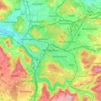
Name: Winterthur topographic map, elevation, terrain.
Location: Winterthur, Bezirk Winterthur, Zurich, Switzerland (47.44972 8.65661 47.54800 8.80994)
Average elevation: 1,654 ft
Minimum elevation: 1,280 ft
Maximum elevation: 2,283 ft
Make a donation
Gear up for your next adventure:
As an Amazon Associate, this site earns from qualifying purchases at no extra cost to you.