
Village of Medina topographic map
Interactive map
Click on the map to display elevation.
About this map
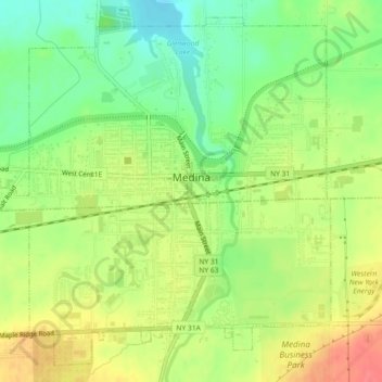
Name: Village of Medina topographic map, elevation, terrain.
Average elevation: 535 ft
Minimum elevation: 436 ft
Maximum elevation: 643 ft
Other topographic maps
Click on a map to view its topography, its elevation and its terrain.
Brockville
United States > New York > Orleans County > Town of Murray
Brockville, Town of Murray, Orleans County, New York, 14452, United States
Average elevation: 489 ft
Village of Albion
United States > New York > Orleans County > Town of Albion
Village of Albion, Town of Albion, Barre, Orleans County, New York, 14411, United States
Average elevation: 541 ft
Town of Albion
United States > New York > Orleans County > Town of Albion
Town of Albion, Orleans County, New York, 14411, United States
Average elevation: 561 ft
West Kendall
United States > New York > Orleans County > Town of Kendall
West Kendall, Town of Kendall, Orleans County, New York, 14476, United States
Average elevation: 328 ft
Waterport
United States > New York > Orleans County > Town of Carlton
Waterport, Town of Carlton, Orleans County, New York, 14571, United States
Average elevation: 351 ft