
La Besurta topographic map
Interactive map
Click on the map to display elevation.
About this map
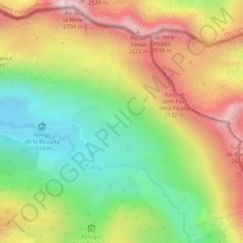
Name: La Besurta topographic map, elevation, terrain.
Location: La Besurta, Benasque, Ribagorce, Huesca, Aragon, Espagne (42.67113 0.64543 42.69113 0.66543)
Average elevation: 7,267 ft
Minimum elevation: 6,040 ft
Maximum elevation: 8,720 ft
Other topographic maps
Click on a map to view its topography, its elevation and its terrain.
Refuge de la Rencluse
Refuge de la Rencluse, Camino de Aigualluts, Benasque, Ribagorce, Huesca, Aragon, 22440, Espagne
Average elevation: 7,336 ft