Geolocate

Muzzano topographic map

Click on the map to display elevation.

About this map

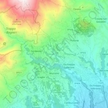
Name: Muzzano topographic map, elevation, terrain.

Location: Muzzano, Biella, Piedmont, Italy (45.54936 7.91790 45.59451 8.00732)

Average elevation: 2,198 ft

Minimum elevation: 1,191 ft

Maximum elevation: 4,997 ft

Other topographic maps

Click on a map to view its topography, its elevation and its terrain.

Campiglia

Italy > Piedmont > Biella > Netro

Average elevation: 2,887 ft

Asei

Italy > Piedmont > Biella > Sostegno

Average elevation: 1,243 ft

Il Gorgomoro

Italy > Piedmont > Biella > Biella > Cossila San Grato

Average elevation: 1,617 ft

Centro Zegna

Italy > Piedmont > Biella > Guala

Average elevation: 2,618 ft

Bielmonte

Italy > Piedmont > Biella > Piatto

Average elevation: 3,793 ft

Malpensà

Italy > Piedmont > Biella > Campiglia Cervo

Average elevation: 3,606 ft

San Giovanni

Italy > Piedmont > Biella > Campiglia Cervo

Average elevation: 3,924 ft

Borgata Brughiera

Italy > Piedmont > Biella > Bulliana

Average elevation: 2,644 ft

Gear up for your next adventure:

🩳Quick‑Dry Hiking Shorts - Comfortable and quick‑dry shorts for summer hiking
😴Insulated Sleeping Pads - Compact and warm pads for high-elevation camping
🪶Camp Gear Gift Set - Perfect gift bundle for outdoor fans
💧Water Purification System - Clean water on the trail with reliable purifiers
🧭Orienteering Set - Complete compass and map reading kit

As an Amazon Associate, this site earns from qualifying purchases at no extra cost to you.