
Make a donation
Gear up for your next adventure:
As an Amazon Associate, this site earns from qualifying purchases at no extra cost to you.
Gstaad topographic map
Click on the map to display elevation.
Make a donation
Gear up for your next adventure:
As an Amazon Associate, this site earns from qualifying purchases at no extra cost to you.
About this map
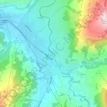
Name: Gstaad topographic map, elevation, terrain.
Average elevation: 4,085 ft
Minimum elevation: 3,314 ft
Maximum elevation: 6,306 ft
Make a donation
Gear up for your next adventure:
As an Amazon Associate, this site earns from qualifying purchases at no extra cost to you.
Other topographic maps
Click on a map to view its topography, its elevation and its terrain.
Boltigen
Switzerland > Bern > Obersimmental-Saanen administrative district
The municipality includes the cooperative farms (Bäuerten) of Boltigen, Adlemsried, Eschi, Oberbäuert (which includes Littisbach and Unterbächen), Reidenbach, Schwarzenmatt, Simmenegg and Weissenbach. The area includes the valley floor around the Simme River, both sides of the valley and the surrounding…
Average elevation: 4,787 ft