
Make a donation
Gear up for your next adventure:
As an Amazon Associate, this site earns from qualifying purchases at no extra cost to you.
Parnamirim topographic map
Click on the map to display elevation.
Make a donation
Gear up for your next adventure:
As an Amazon Associate, this site earns from qualifying purchases at no extra cost to you.
Parnamirim
Parnamirim belongs to the Intermediate Geographic Region of Natal and the Metropolitan Region of Natal. It is located on the coast with Atlantic Ocean, about 13 kilometers south of the urban center of Natal. Its average elevation is 48 meters above the sea level.
Make a donation
Gear up for your next adventure:
As an Amazon Associate, this site earns from qualifying purchases at no extra cost to you.
About this map
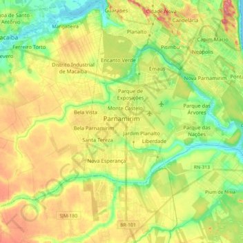
Name: Parnamirim topographic map, elevation, terrain.
Average elevation: 157 ft
Minimum elevation: 0 ft
Maximum elevation: 351 ft
Make a donation
Gear up for your next adventure:
As an Amazon Associate, this site earns from qualifying purchases at no extra cost to you.
Other topographic maps
Click on a map to view its topography, its elevation and its terrain.