
Upton Heath Nature Reserve topographic map
Interactive map
Click on the map to display elevation.
About this map
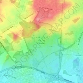
Name: Upton Heath Nature Reserve topographic map, elevation, terrain.
Average elevation: 131 ft
Minimum elevation: 13 ft
Maximum elevation: 292 ft
Other topographic maps
Click on a map to view its topography, its elevation and its terrain.
Poole
United Kingdom > England > Bournemouth, Christchurch and Poole > Poole
Poole, Bournemouth, Christchurch and Poole, England, United Kingdom
Average elevation: 75 ft
Holes Bay
United Kingdom > England > Bournemouth, Christchurch and Poole > Poole
Holes Bay, Sterte, Poole, Bournemouth, Christchurch and Poole, South West England, England, BH15 2BD, United Kingdom
Average elevation: 13 ft