Geolocate

Lagos topographic map

Click on the map to display elevation.

About this map

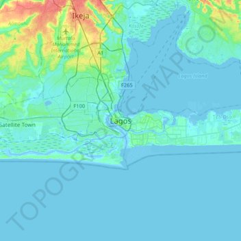
Name: Lagos topographic map, elevation, terrain.

Location: Lagos, Lagos Island, Lagos State, 100242, Nigeria (6.29506 3.23418 6.61506 3.55418)

Average elevation: 16 ft

Minimum elevation: -16 ft

Maximum elevation: 161 ft

Other topographic maps

Click on a map to view its topography, its elevation and its terrain.

Freedom Park

Nigeria > Lagos State > Lagos Island > Lagos

Average elevation: 16 ft

Freedom Park

Nigeria > Lagos State > Lagos Island > Lagos

Average elevation: 16 ft

Lagos Lagoon

Nigeria > Lagos State > Lagos Island

Average elevation: 33 ft

Freedom Park

Nigeria > Lagos State > Lagos Island > Lagos

Average elevation: 16 ft

Gear up for your next adventure:

🪶Wildlife Field Guides - Learn animal tracking and species ID
🌎3D Topographic Globes - Raised relief globes for a tactile understanding of geography
🧣Hiking Neck Gaiter - Multi‑use neck protection for outdoor weather
📶Vehicle Signal Boosters - Improve reception in rural areas while driving to trailheads
🦶Carbon Trekking Poles - Reduce knee impact on steep descents with ultra-light poles

As an Amazon Associate, this site earns from qualifying purchases at no extra cost to you.