
Atwood topographic map
Interactive map
Click on the map to display elevation.
About this map
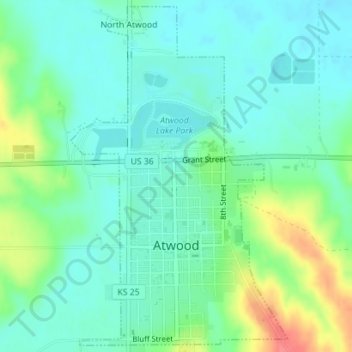
Name: Atwood topographic map, elevation, terrain.
Location: Atwood, Rawlins County, Kansas, United States (39.79895 -101.05268 39.82499 -101.03095)
Average elevation: 2,877 ft
Minimum elevation: 2,818 ft
Maximum elevation: 3,031 ft
Other topographic maps
Click on a map to view its topography, its elevation and its terrain.
Herndon
United States > Kansas > Rawlins County
Herndon, Rawlins County, Kansas, 67739, United States
Average elevation: 2,710 ft