
Town of Jacksonport topographic map
Interactive map
Click on the map to display elevation.
About this map
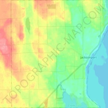
Name: Town of Jacksonport topographic map, elevation, terrain.
Location: Town of Jacksonport, Door County, Wisconsin, United States (44.93687 -87.27565 45.02549 -87.15154)
Average elevation: 673 ft
Minimum elevation: 564 ft
Maximum elevation: 837 ft
Other topographic maps
Click on a map to view its topography, its elevation and its terrain.
Little Sturgeon
United States > Wisconsin > Door County
Little Sturgeon, Town of Gardner, Door County, Wisconsin, United States
Average elevation: 587 ft
Brussels
United States > Wisconsin > Door County
Brussels, Town of Brussels, Door County, Wisconsin, 54204, United States
Average elevation: 745 ft
Town of Egg Harbor
United States > Wisconsin > Door County
Town of Egg Harbor, Door County, Wisconsin, 54209, United States
Average elevation: 643 ft
Fish Creek
United States > Wisconsin > Door County > Fish Creek
Fish Creek, Town of Gibraltar, Door County, Wisconsin, 54212, United States
Average elevation: 620 ft
Ellison Bay
United States > Wisconsin > Door County
Ellison Bay, Town of Liberty Grove, Door County, Wisconsin, 54210, United States
Average elevation: 636 ft
Sturgeon Bay
United States > Wisconsin > Door County
Sturgeon Bay, Door County, Wisconsin, 54235, United States
Average elevation: 653 ft
Egg Harbor
United States > Wisconsin > Door County
Egg Harbor, Door County, Wisconsin, United States
Average elevation: 636 ft