
Chhatrapati Sambhajinagar topographic map
Interactive map
Click on the map to display elevation.
About this map
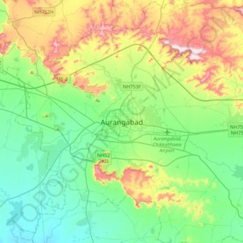
Name: Chhatrapati Sambhajinagar topographic map, elevation, terrain.
Location: Chhatrapati Sambhajinagar, Maharashtra, 431002, India (19.71726 75.17902 20.03726 75.49902)
Average elevation: 2,028 ft
Minimum elevation: 1,581 ft
Maximum elevation: 3,064 ft
Other topographic maps
Click on a map to view its topography, its elevation and its terrain.
Nipani
India > Maharashtra > Chhatrapati Sambhajinagar
Nipani, Chhatrapati Sambhajinagar, Chhatrapati Sambhajinagar District, Maharashtra, 431007, India
Average elevation: 1,837 ft