
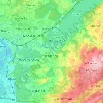
Riedering topographic map
Interactive map
Click on the map to display elevation.
About this map
Name: Riedering topographic map, elevation, terrain.
Location: Riedering, Landkreis Rosenheim, Bayern, 83083, Deutschland (47.80963 12.16879 47.87600 12.29223)
Average elevation: 1,667 ft
Minimum elevation: 1,437 ft
Maximum elevation: 2,149 ft
Other topographic maps
Click on a map to view its topography, its elevation and its terrain.
Bruckmühl
Deutschland > Bayern > Landkreis Rosenheim
Bruckmühl, Landkreis Rosenheim, Bayern, 83052, Deutschland
Average elevation: 1,795 ft
Stephanskirchen
Deutschland > Bayern > Landkreis Rosenheim
Stephanskirchen, Landkreis Rosenheim, Bayern, 83071, Deutschland
Average elevation: 1,588 ft
Leonhardspfunzen
Deutschland > Bayern > Landkreis Rosenheim > Stephanskirchen
Leonhardspfunzen, Stephanskirchen, Landkreis Rosenheim, Bayern, Deutschland
Average elevation: 1,549 ft