
Marsol topographic map
Interactive map
Click on the map to display elevation.
About this map
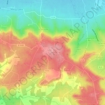
Name: Marsol topographic map, elevation, terrain.
Average elevation: 384 ft
Minimum elevation: 161 ft
Maximum elevation: 600 ft
Other topographic maps
Click on a map to view its topography, its elevation and its terrain.
Combet
France > Nouvelle-Aquitaine > Dordogne > Monbazillac > Combet
Combet, Monbazillac, Bergerac, Dordogne, Nouvelle-Aquitaine, France métropolitaine, 24240, France
Average elevation: 400 ft
Les Barses
France > Nouvelle-Aquitaine > Dordogne > Monbazillac > Le Peyroudier
Les Barses, Le Peyroudier, Monbazillac, Bergerac, Dordogne, Nouvelle-Aquitaine, France métropolitaine, 24240, France
Average elevation: 249 ft
Bernasse
France > Nouvelle-Aquitaine > Dordogne > Monbazillac
Bernasse, Monbazillac, Bergerac, Dordogne, Nouvelle-Aquitaine, France métropolitaine, 24240, France
Average elevation: 413 ft