Geolocate

Benin City topographic map

Click on the map to display elevation.

About this map

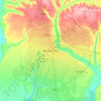
Name: Benin City topographic map, elevation, terrain.

Location: Benin City, Oredo, Edo State, 300241, Nigeria (6.17306 5.46211 6.49306 5.78211)

Average elevation: 236 ft

Minimum elevation: 7 ft

Maximum elevation: 581 ft

Other topographic maps

Click on a map to view its topography, its elevation and its terrain.

River Ogba

Nigeria > Edo State > Oredo

Average elevation: 59 ft

River Ogba

Nigeria > Edo State > Oredo

Average elevation: 59 ft

Gear up for your next adventure:

🦟Ultrasonic Repellers - Create a bug-free zone at your camp or rest stop
Backpacking Tents - Weight-optimized shelters for multi-day topographic surveys
🔭Compact Binoculars - HD vision for scouting terrain and identifying distant landmarks
🧤Tactile Hiking Gloves - Keep hands warm while operating GPS and smartphone screens
👟Trail Running Shoes - Lightweight shoes for trail runners

As an Amazon Associate, this site earns from qualifying purchases at no extra cost to you.