
Ujjani topographic map
Interactive map
Click on the map to display elevation.
About this map
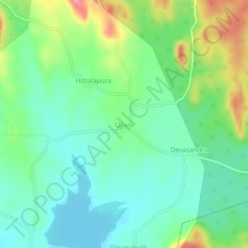
Name: Ujjani topographic map, elevation, terrain.
Average elevation: 2,352 ft
Minimum elevation: 2,241 ft
Maximum elevation: 2,589 ft
Other topographic maps
Click on a map to view its topography, its elevation and its terrain.
Sugganahalli
India > Karnataka > Kunigal taluk
Sugganahalli, Kunigal taluk, Tumakuru District, Karnataka, India
Average elevation: 2,218 ft
Kunigal
India > Karnataka > Kunigal taluk
Kunigal, Kunigal taluk, Tumkur district, Karnataka, 572130, India
Average elevation: 2,543 ft