
San Simón topographic map
Interactive map
Click on the map to display elevation.
About this map
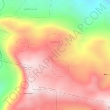
Name: San Simón topographic map, elevation, terrain.
Average elevation: 2,090 ft
Minimum elevation: 610 ft
Maximum elevation: 2,989 ft
Other topographic maps
Click on a map to view its topography, its elevation and its terrain.
Valle de Las Vegas
Venezuela > Sucre State > Municipio Sucre
Valle de Las Vegas, Parroquia Raúl Leoni, Municipio Sucre, Sucre State, Venezuela
Average elevation: 2,218 ft
Cumana
Venezuela > Sucre State > Municipio Sucre
Cumana, Parroquia Santa Inés, Municipio Sucre, Sucre State, 6101, Venezuela
Average elevation: 285 ft
Ortíz
Venezuela > Sucre State > Municipio Sucre
Ortíz, Parroquia Santa Inés, Municipio Sucre, Sucre State, Venezuela
Average elevation: 1,096 ft
El Pirata
Venezuela > Sucre State > Municipio Sucre > El Pirata
El Pirata, Parroquia Ayacucho, Municipio Sucre, Sucre State, Venezuela
Average elevation: 13 ft
Las Marías
Venezuela > Sucre State > Municipio Sucre
Las Marías, Parroquia Raúl Leoni, Municipio Sucre, Sucre State, Venezuela
Average elevation: 1,365 ft