
Make a donation
Gear up for your next adventure:
As an Amazon Associate, this site earns from qualifying purchases at no extra cost to you.
Qarağandı city administration topographic map
Click on the map to display elevation.
Make a donation
Gear up for your next adventure:
As an Amazon Associate, this site earns from qualifying purchases at no extra cost to you.
Qarağandı city administration
Karaganda suffered the most severe electromagnetic pulse effects ever observed when its electrical power plant was set on fire by currents induced in a 1,000 km (620 mi) long shallow buried power cable by Soviet Test ‘184’ on 22 October 1962. The test was part of the Soviet Project K nuclear tests (ABM System A proof tests), and consisted of a 300-kiloton high-altitude nuclear explosion at an altitude of 290 km (180 mi) over Zhezkazgan.
Make a donation
Gear up for your next adventure:
As an Amazon Associate, this site earns from qualifying purchases at no extra cost to you.
About this map
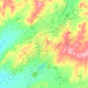
Name: Qarağandı city administration topographic map, elevation, terrain.
Location: Qarağandı city administration, Karaganda Region, Kazakhstan (49.68282 72.97522 49.99427 73.27738)
Average elevation: 1,778 ft
Minimum elevation: 1,594 ft
Maximum elevation: 2,116 ft
Make a donation
Gear up for your next adventure:
As an Amazon Associate, this site earns from qualifying purchases at no extra cost to you.
Other topographic maps
Click on a map to view its topography, its elevation and its terrain.