
Mount Katmai topographic map
Interactive map
Click on the map to display elevation.
About this map
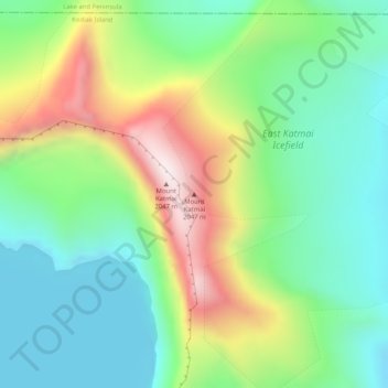
Name: Mount Katmai topographic map, elevation, terrain.
Location: Mount Katmai, Kodiak Island, Alaska, United States (58.27810 -154.94965 58.27820 -154.94955)
Average elevation: 4,944 ft
Minimum elevation: 4,163 ft
Maximum elevation: 6,457 ft
Mount Katmai (Russian: Катмай) is a large stratovolcano (composite volcano) on the Alaska Peninsula in southern Alaska, located within Katmai National Park and Preserve. It is about 6.3 miles (10 km) in diameter with a central lake-filled caldera about two by three miles (3.2 by 4.8 km) in size, formed during the Novarupta eruption of 1912. The caldera rim reaches a maximum elevation of 6,716 feet (2,047 m). In 1975 the surface of the crater lake was at an elevation of about 4,220 feet (1,286 m), and the estimated elevation of the caldera floor is about 3,400 ft (1,040 m). The mountain is located in Kodiak Island Borough, very close to its border with Lake and Peninsula Borough.
Other topographic maps
Click on a map to view its topography, its elevation and its terrain.
Raspberry Island
United States > Alaska > Kodiak Island
Raspberry Island, Kodiak Island, Alaska, United States
Average elevation: 233 ft
Woody Island
United States > Alaska > Kodiak Island
Woody Island, Kodiak Island, Alaska, United States
Average elevation: 30 ft
Trident Volcano
United States > Alaska > Kodiak Island
Trident Volcano, Kodiak Island, Alaska, United States
Average elevation: 4,390 ft
Kodiak
United States > Alaska > Kodiak Island
Kodiak, Kodiak Island, Alaska, United States
Average elevation: 203 ft