
Make a donation
Gear up for your next adventure:
As an Amazon Associate, this site earns from qualifying purchases at no extra cost to you.
Meknes topographic map
Click on the map to display elevation.
Make a donation
Gear up for your next adventure:
As an Amazon Associate, this site earns from qualifying purchases at no extra cost to you.
Meknes
Each year Meknes holds the International Agriculture Show in Morocco (French: Salon International de l'Agriculture au Maroc) since April 2006. This agriculture show has an area of more than 250000 square meters, with more than 60 countries participating, and more than 1200 exhibitors. The lands around Meknes area are known to be fertile and productive. The high elevation, fertility and the fresh water of those lands favor the cultivation of fruits and vegetables, most notably: peaches, nectarines, prunes, apples, potatoes, onions and garlic. Meknes is also known for its olives and olive oil. Livestock raising, particularly sheep and cattle, is widespread. Meknes has large industrial units for milk and dairy production that fulfill most of the needs of the region.
Make a donation
Gear up for your next adventure:
As an Amazon Associate, this site earns from qualifying purchases at no extra cost to you.
About this map
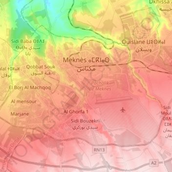
Name: Meknes topographic map, elevation, terrain.
Average elevation: 1,742 ft
Minimum elevation: 1,020 ft
Maximum elevation: 2,139 ft
Make a donation
Gear up for your next adventure:
As an Amazon Associate, this site earns from qualifying purchases at no extra cost to you.