
Make a donation
Gear up for your next adventure:
As an Amazon Associate, this site earns from qualifying purchases at no extra cost to you.
Bizerte topographic map
Click on the map to display elevation.
Make a donation
Gear up for your next adventure:
As an Amazon Associate, this site earns from qualifying purchases at no extra cost to you.
Bizerte
The bridge leads to the motorway A4 leading to Tunis–Carthage International Airport and the capital. On the town side the P11 passes semi-rural Louata, hugs Ichkeul Lake and branches into a western route, the P7, leading directly to Tabarka on the coast next to the Algerian border. The P11 leads south-west to Béja, a governorate center, in the foothills of the Tell Atlas, forks into several roads at Bou Salem, a small town in a broad fertile plain, and climbs to Firnanah passing two high-altitude lakes and also approaching the north-west border with Algeria.
Make a donation
Gear up for your next adventure:
As an Amazon Associate, this site earns from qualifying purchases at no extra cost to you.
About this map
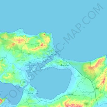
Name: Bizerte topographic map, elevation, terrain.
Average elevation: 92 ft
Minimum elevation: -20 ft
Maximum elevation: 1,266 ft
Make a donation
Gear up for your next adventure:
As an Amazon Associate, this site earns from qualifying purchases at no extra cost to you.