
Make a donation
Gear up for your next adventure:
As an Amazon Associate, this site earns from qualifying purchases at no extra cost to you.
Nagqu topographic map
Click on the map to display elevation.
Make a donation
Gear up for your next adventure:
As an Amazon Associate, this site earns from qualifying purchases at no extra cost to you.
Nagqu
Nagqu is located in the northeast of Tibet. Nagqu Town is 330 kilometres (210 mi) by the China National Highway 109 northeast of Lhasa. Nagqu is bordered by Bayingolin and Hotan Prefectures of Xinjiang to the north, Haixi, Yushu Prefectures of Qinghai and Chamdo to the east, Nyingchi, Lhasa and Shigatse to the south, and Ngari Prefecture to the west. It covers an area of 450,537 km2 (173,953 sq mi).) It lies on the southern slope of Tanggula Mountains, on the north side of Nyenchen Tanglha Mountains, and on the eastern end of the Changtang Plateau. The average altitude is more than 4,500 meters (14,800 ft) above sea level. Principal towns in the region include Nagqu Town, Amdo, Nyainrong and Xainza.
Make a donation
Gear up for your next adventure:
As an Amazon Associate, this site earns from qualifying purchases at no extra cost to you.
About this map
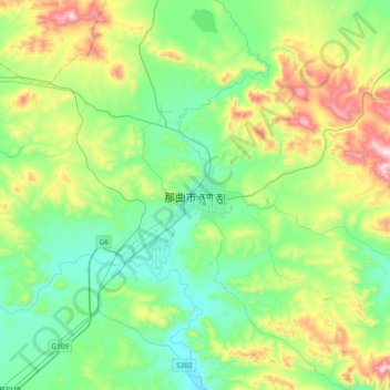
Name: Nagqu topographic map, elevation, terrain.
Location: Nagqu, Seni District, Nagqu City, Tibet, China (31.31862 91.88981 31.63862 92.20981)
Average elevation: 15,171 ft
Minimum elevation: 14,606 ft
Maximum elevation: 16,617 ft
Make a donation
Gear up for your next adventure:
As an Amazon Associate, this site earns from qualifying purchases at no extra cost to you.