
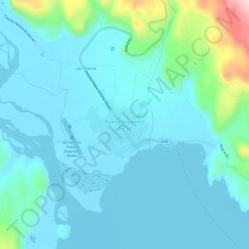
Puerto Ingeniero Ibáñez topographic map
Interactive map
Click on the map to display elevation.
About this map
Name: Puerto Ingeniero Ibáñez topographic map, elevation, terrain.
Average elevation: 814 ft
Minimum elevation: 653 ft
Maximum elevation: 1,736 ft
La Reserva Nacional Cerro Castillo, con sus imponentes cumbres destacable de sobremanera el Cerro Castillo, con una altitud cercana a los 3000 msnm y con presencia de nieve durante todo el año, además el paredón de las manos.