
Make a donation
Gear up for your next adventure:
As an Amazon Associate, this site earns from qualifying purchases at no extra cost to you.
Río Clarillo National Reserve topographic map
Click on the map to display elevation.
Make a donation
Gear up for your next adventure:
As an Amazon Associate, this site earns from qualifying purchases at no extra cost to you.
About this map
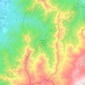
Name: Río Clarillo National Reserve topographic map, elevation, terrain.
Average elevation: 5,971 ft
Minimum elevation: 2,254 ft
Maximum elevation: 11,857 ft
Make a donation
Gear up for your next adventure:
As an Amazon Associate, this site earns from qualifying purchases at no extra cost to you.
Other topographic maps
Click on a map to view its topography, its elevation and its terrain.
Santa Rita Sur
Chile > Santiago Metropolitan Region > Provincia de Cordillera
Average elevation: 2,493 ft
Tupungato
Chile > Santiago Metropolitan Region > Provincia de Cordillera > San José de Maipo
Average elevation: 19,692 ft
Tupungato
Chile > Santiago Metropolitan Region > Provincia de Cordillera > San José de Maipo
Average elevation: 19,692 ft
San Alfonso
Chile > Santiago Metropolitan Region > Provincia de Cordillera > San José de Maipo
Average elevation: 4,501 ft
Make a donation
Gear up for your next adventure:
As an Amazon Associate, this site earns from qualifying purchases at no extra cost to you.
Cerro Penitentes
Chile > Santiago Metropolitan Region > Provincia de Cordillera > San José de Maipo
Average elevation: 12,195 ft
Cerro Alvarado
Chile > Santiago Metropolitan Region > Provincia de Cordillera > San José de Maipo
Average elevation: 12,917 ft
Cerro Tórtolas
Chile > Santiago Metropolitan Region > Provincia de Cordillera > San José de Maipo
Average elevation: 11,929 ft
El Peumo Poniente
Chile > Santiago Metropolitan Region > Provincia de Cordillera > San José de Maipo > El Peumo Poniente
Average elevation: 3,629 ft
Make a donation
Gear up for your next adventure:
As an Amazon Associate, this site earns from qualifying purchases at no extra cost to you.