
General Pedernera topographic map
Interactive map
Click on the map to display elevation.
About this map
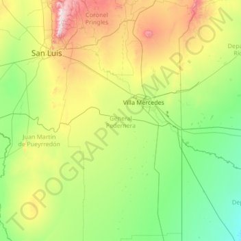
Name: General Pedernera topographic map, elevation, terrain.
Location: General Pedernera, San Luis, Argentine (-34.71326 -66.21812 -32.90680 -64.99883)
Average elevation: 1,900 ft
Minimum elevation: 715 ft
Maximum elevation: 7,142 ft
Other topographic maps
Click on a map to view its topography, its elevation and its terrain.
Villa Mercedes
Villa Mercedes, Municipio de Villa Mercedes, General Pedernera, San Luis, D5730, Argentine
Average elevation: 1,709 ft
San Francisco del Monte de Oro
Argentine > San Luis > San Francisco del Monte de Oro
San Francisco del Monte de Oro, Municipio de San Francisco del Monte de Oro, Ayacucho, San Luis, Argentine
Average elevation: 2,644 ft