
Louvois topographic map
Interactive map
Click on the map to display elevation.
About this map
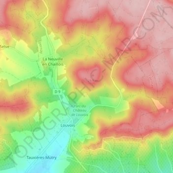
Name: Louvois topographic map, elevation, terrain.
Average elevation: 679 ft
Minimum elevation: 335 ft
Maximum elevation: 955 ft
Other topographic maps
Click on a map to view its topography, its elevation and its terrain.
Château de Louvois
France > Grand Est > Marne > Val de Livre
Château de Louvois, Allée des Dames de France, Louvois, Val de Livre, Épernay, Marne, Grand Est, France métropolitaine, 51150, France
Average elevation: 571 ft
Hameau de Vertuelle
France > Grand Est > Marne > Val de Livre
Hameau de Vertuelle, Louvois, Val de Livre, Épernay, Marne, Grand Est, France métropolitaine, 51150, France
Average elevation: 702 ft
Tauxières-Mutry
France > Grand Est > Marne > Val de Livre
Tauxières-Mutry, Val de Livre, Épernay, Marne, Grand Est, France métropolitaine, 51150, France
Average elevation: 518 ft