
Nosrat Abad topographic map
Interactive map
Click on the map to display elevation.
About this map
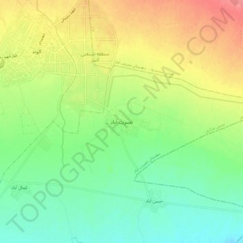
Name: Nosrat Abad topographic map, elevation, terrain.
Location: Nosrat Abad, بخش مرکزی, Alborz County, Qazvin Province, Iran (36.12342 50.05882 36.20342 50.13882)
Average elevation: 4,035 ft
Minimum elevation: 3,930 ft
Maximum elevation: 4,183 ft
Other topographic maps
Click on a map to view its topography, its elevation and its terrain.
Nosrat Abad
Iran > Qazvin Province > Alborz County > Nosratabad RD
Nosrat Abad, Nosratabad RD, Alborz Central District, Alborz County, Qazvin Province, Iran
Average elevation: 4,026 ft