
Mohanlalganj topographic map
Interactive map
Click on the map to display elevation.
About this map
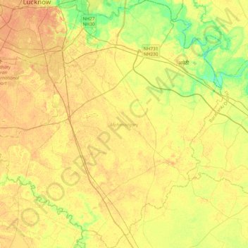
Name: Mohanlalganj topographic map, elevation, terrain.
Location: Mohanlalganj, Lucknow, Uttar Pradesh, India (26.50377 80.86279 26.84268 81.21698)
Average elevation: 384 ft
Minimum elevation: 325 ft
Maximum elevation: 420 ft
Other topographic maps
Click on a map to view its topography, its elevation and its terrain.
Nagram
India > Uttar Pradesh > Mohanlalganj
Nagram, Mohanlalganj, Lucknow, Uttar Pradesh, 226303, India
Average elevation: 387 ft