
Lake Mapanuepe topographic map
Interactive map
Click on the map to display elevation.
About this map
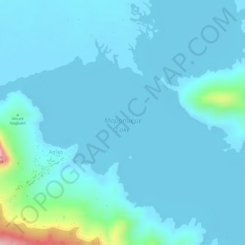
Name: Lake Mapanuepe topographic map, elevation, terrain.
Location: Lake Mapanuepe, Aglao, Zambales, Central Luzon, Philippines (14.98333 120.29154 14.98343 120.29164)
Average elevation: 479 ft
Minimum elevation: 410 ft
Maximum elevation: 1,050 ft
Other topographic maps
Click on a map to view its topography, its elevation and its terrain.
Mapanuepe Lake
Philippines > Zambales > Aglao
Mapanuepe Lake, Aglao, Zambales, Central Luzon, Philippines
Average elevation: 617 ft