
Mazowe River topographic map
Interactive map
Click on the map to display elevation.
About this map
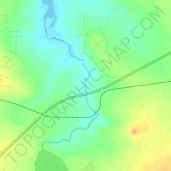
Name: Mazowe River topographic map, elevation, terrain.
Location: Mazowe River, Mazowe, Mashonaland Central, Zimbabwe (-17.36674 31.08062 -17.34655 31.08994)
Average elevation: 3,698 ft
Minimum elevation: 3,635 ft
Maximum elevation: 3,770 ft
Other topographic maps
Click on a map to view its topography, its elevation and its terrain.
Ruya River
Zimbabwe > Mashonaland Central
Ruya River, Bindura, Mashonaland Central, Zimbabwe
Average elevation: 3,894 ft
Bindura
Zimbabwe > Mashonaland Central
Bindura, Mashonaland Central, Zimbabwe
Average elevation: 3,891 ft
Mount Darwin
Zimbabwe > Mashonaland Central
Mount Darwin, Mashonaland Central, Zimbabwe
Average elevation: 2,628 ft
Mutungagore
Zimbabwe > Mashonaland Central
Mutungagore, Shamva, Mashonaland Central, Zimbabwe
Average elevation: 3,022 ft
Centenary
Zimbabwe > Mashonaland Central > Centenary
Centenary, Muzarabani, Mashonaland Central, Zimbabwe
Average elevation: 3,934 ft