
Molbergen topographic map
Interactive map
Click on the map to display elevation.
About this map
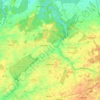
Name: Molbergen topographic map, elevation, terrain.
Location: Molbergen, Landkreis Cloppenburg, Nedersaksen, 49696, Duitsland (52.81683 7.79186 52.93660 7.99996)
Average elevation: 112 ft
Minimum elevation: 56 ft
Maximum elevation: 167 ft
Other topographic maps
Click on a map to view its topography, its elevation and its terrain.
Saterland - Seelterlound
Duitsland > Nedersaksen > Landkreis Cloppenburg
Saterland - Seelterlound, Landkreis Cloppenburg, Nedersaksen, 26683, Duitsland
Average elevation: 16 ft
Barßel
Duitsland > Nedersaksen > Landkreis Cloppenburg
Barßel, Landkreis Cloppenburg, Nedersaksen, 26676, Duitsland
Average elevation: 13 ft
Addrup
Duitsland > Nedersaksen > Landkreis Cloppenburg > Essen (Oldenburg)
Addrup, Dorfgemeinschaft Addrup, Essen (Oldenburg), Landkreis Cloppenburg, Nedersaksen, Duitsland
Average elevation: 92 ft
Neuvrees
Duitsland > Nedersaksen > Landkreis Cloppenburg > Friesoythe
Neuvrees, Friesoythe, Landkreis Cloppenburg, Nedersaksen, 26169, Duitsland
Average elevation: 46 ft
Lindern (Oldenburg)
Duitsland > Nedersaksen > Landkreis Cloppenburg > Lindern (Oldenburg)
Lindern (Oldenburg), Landkreis Cloppenburg, Nedersaksen, 49699, Duitsland
Average elevation: 108 ft
Cloppenburg
Duitsland > Nedersaksen > Landkreis Cloppenburg
Cloppenburg, Landkreis Cloppenburg, Nedersaksen, 49661, Duitsland
Average elevation: 135 ft