Geolocate

Berkeley Heights topographic map

Click on the map to display elevation.

About this map

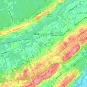
Name: Berkeley Heights topographic map, elevation, terrain.

Location: Berkeley Heights, Union County, New Jersey, 07922, United States (40.65420 -74.46123 40.69875 -74.37945)

Average elevation: 302 ft

Minimum elevation: 138 ft

Maximum elevation: 577 ft

Union County trails, hiking, mountain biking, running and outdoor activities

Other topographic maps

Click on a map to view its topography, its elevation and its terrain.

Woodland Park

United States > New Jersey > Union County > Summit

Average elevation: 361 ft

Sunnyside

United States > New Jersey > Union County > Linden

Average elevation: 56 ft

Tremley

United States > New Jersey > Union County > Linden

Average elevation: 13 ft

Woodland Park

United States > New Jersey > Union County > Summit

Average elevation: 361 ft

Tremont Park

United States > New Jersey > Union County > Summit

Average elevation: 335 ft

Gear up for your next adventure:

🧣Hiking Neck Gaiter - Multi‑use neck protection for outdoor weather
🪄Magnetic Compass - Accurate compass for navigation
🔥Camping Stove - Portable stove for camping and backcountry cooking
🔦Powerful Headlamps - Ultra-bright hands-free lighting for night navigation
👟Men's Trail Runners - Lightweight footwear for fast-paced exploration and light hiking

As an Amazon Associate, this site earns from qualifying purchases at no extra cost to you.