Geolocate

Ashill topographic map

Click on the map to display elevation.

About this map

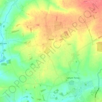
Name: Ashill topographic map, elevation, terrain.

Location: Ashill, Breckland District, Norfolk, England, United Kingdom (52.57817 0.74381 52.62051 0.83624)

Average elevation: 187 ft

Minimum elevation: 92 ft

Maximum elevation: 305 ft

Gear up for your next adventure:

🧷Carabiner Set - Durable clips for gear attachment
🪵Folding Camp Saw - Compact saw for wood and campsite work
🥩Freeze-Dried Meals - Nutritious and lightweight food for remote expeditions
Backpacking Tent - Lightweight and durable tent for multi‑day hikes
🧭Pro Hiking Compasses - High-accuracy liquid-filled compasses for topographic orientation

As an Amazon Associate, this site earns from qualifying purchases at no extra cost to you.