
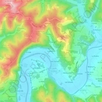
La Maletie topographic map
Interactive map
Click on the map to display elevation.
About this map
Name: La Maletie topographic map, elevation, terrain.
Average elevation: 433 ft
Minimum elevation: 210 ft
Maximum elevation: 856 ft
Other topographic maps
Click on a map to view its topography, its elevation and its terrain.
Monbazillac
France > Nouvelle-Aquitaine > Dordogne > Saint-Léon-sur-Vézère > Monbazillac
Monbazillac, Saint-Léon-sur-Vézère, Sarlat-la-Canéda, Dordogne, Nouvelle-Aquitaine, France métropolitaine, 24290, France
Average elevation: 413 ft
Le Sol
France > Nouvelle-Aquitaine > Dordogne > Saint-Léon-sur-Vézère
Le Sol, Saint-Léon-sur-Vézère, Sarlat-la-Canéda, Dordogne, Nouvelle-Aquitaine, France métropolitaine, 24290, France
Average elevation: 436 ft
Les Granges
France > Nouvelle-Aquitaine > Dordogne > Saint-Léon-sur-Vézère
Les Granges, Saint-Léon-sur-Vézère, Sarlat-la-Canéda, Dordogne, Nouvelle-Aquitaine, France métropolitaine, 24290, France
Average elevation: 420 ft