
Make a donation
Gear up for your next adventure:
As an Amazon Associate, this site earns from qualifying purchases at no extra cost to you.
Budva topographic map
Click on the map to display elevation.
Make a donation
Gear up for your next adventure:
As an Amazon Associate, this site earns from qualifying purchases at no extra cost to you.
About this map
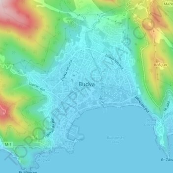
Name: Budva topographic map, elevation, terrain.
Location: Budva, Budva Municipality, Montenegro (42.27347 18.82200 42.30281 18.86104)
Average elevation: 292 ft
Minimum elevation: -7 ft
Maximum elevation: 1,391 ft
Make a donation
Gear up for your next adventure:
As an Amazon Associate, this site earns from qualifying purchases at no extra cost to you.
Other topographic maps
Click on a map to view its topography, its elevation and its terrain.
View over the sea, mountain, and Buljarica beach
Montenegro > Budva Municipality > Buljarica > Bačvice
Average elevation: 95 ft
Make a donation
Gear up for your next adventure:
As an Amazon Associate, this site earns from qualifying purchases at no extra cost to you.