
Make a donation
Gear up for your next adventure:
As an Amazon Associate, this site earns from qualifying purchases at no extra cost to you.
Licantén topographic map
Click on the map to display elevation.
Make a donation
Gear up for your next adventure:
As an Amazon Associate, this site earns from qualifying purchases at no extra cost to you.
About this map
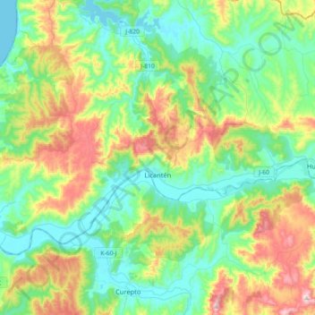
Name: Licantén topographic map, elevation, terrain.
Location: Licantén, Provincia de Curicó, Maule Region, Chile (-35.05932 -72.18708 -34.87945 -71.83108)
Average elevation: 541 ft
Minimum elevation: 0 ft
Maximum elevation: 1,870 ft
Make a donation
Gear up for your next adventure:
As an Amazon Associate, this site earns from qualifying purchases at no extra cost to you.
Other topographic maps
Click on a map to view its topography, its elevation and its terrain.
Peteroa
Chile > Maule Region > Provincia de Curicó > Sagrada Familia > Santa Ana
Average elevation: 456 ft
Zona Central
Chile > Maule Region > Provincia de Curicó > Teno
The topography of central Chile includes a coastal range of mountains running parallel to the Andes. Lying between the two mountain ranges is the so-called Central Valley, which contains some of the richest agricultural land in the country, especially in its northern portion. The area just north and south of…
Average elevation: 3,678 ft