
Samos topographic map
Interactive map
Click on the map to display elevation.
About this map
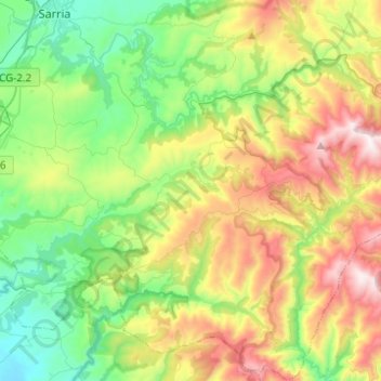
Name: Samos topographic map, elevation, terrain.
Location: Samos, Sarria, Lugo, Galicië, Spanje (42.60339 -7.39270 42.78474 -7.17129)
Average elevation: 2,434 ft
Minimum elevation: 1,148 ft
Maximum elevation: 4,790 ft
Other topographic maps
Click on a map to view its topography, its elevation and its terrain.
Triacastela
Spanje > Galicië > Sarria > Triacastela
Triacastela, Sarria, Lugo, Galicië, Spanje
Average elevation: 2,927 ft