
Make a donation
Gear up for your next adventure:
As an Amazon Associate, this site earns from qualifying purchases at no extra cost to you.
Lilongwe topographic map
Click on the map to display elevation.
Make a donation
Gear up for your next adventure:
As an Amazon Associate, this site earns from qualifying purchases at no extra cost to you.
Lilongwe
Lilongwe is located on a plateau in Central Malawi, forming part of the East African Rift Valley situated at an altitude of 1,050 m (3,440 ft) above sea level, along Lilongwe River.
Make a donation
Gear up for your next adventure:
As an Amazon Associate, this site earns from qualifying purchases at no extra cost to you.
About this map
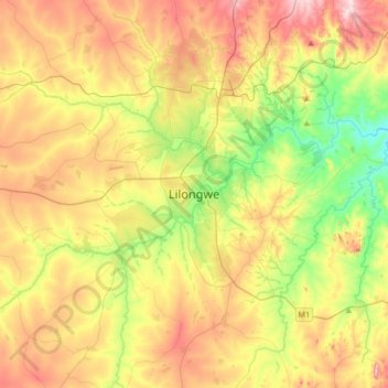
Name: Lilongwe topographic map, elevation, terrain.
Location: Lilongwe, Central Region, Malawi, Malawi (-14.14751 33.60814 -13.82751 33.92814)
Average elevation: 3,615 ft
Minimum elevation: 3,159 ft
Maximum elevation: 4,163 ft
Make a donation
Gear up for your next adventure:
As an Amazon Associate, this site earns from qualifying purchases at no extra cost to you.