
Ngxutyana River topographic map
Interactive map
Click on the map to display elevation.
About this map
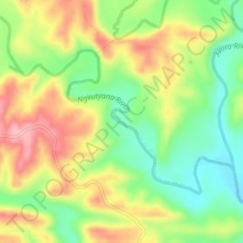
Name: Ngxutyana River topographic map, elevation, terrain.
Average elevation: 289 ft
Minimum elevation: 62 ft
Maximum elevation: 545 ft
Other topographic maps
Click on a map to view its topography, its elevation and its terrain.
Dutywa
South Africa > Eastern Cape > Amathole District Municipality > Mbhashe Local Municipality
Dutywa, Mbhashe Local Municipality, Amathole District Municipality, Eastern Cape, South Africa
Average elevation: 2,733 ft
Mbashe
South Africa > Eastern Cape > Amathole District Municipality > Mbhashe Local Municipality
Mbashe, Mbhashe Ward 21, Mbhashe Local Municipality, Amathole District Municipality, Eastern Cape, South Africa
Average elevation: 217 ft
Ngqatyana
South Africa > Eastern Cape > Amathole District Municipality > Mbhashe Local Municipality
Ngqatyana, Mbhashe Local Municipality, Amathole District Municipality, Eastern Cape, South Africa
Average elevation: 879 ft