
El Zapotalito topographic map
Interactive map
Click on the map to display elevation.
About this map
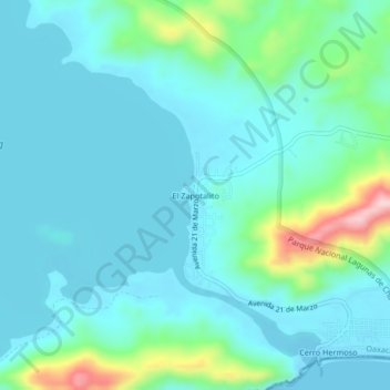
Name: El Zapotalito topographic map, elevation, terrain.
Location: El Zapotalito, Tututepec, Oaxaca, Mexico (15.96607 -97.56999 16.00607 -97.52999)
Average elevation: 148 ft
Minimum elevation: -13 ft
Maximum elevation: 837 ft
Other topographic maps
Click on a map to view its topography, its elevation and its terrain.
San Isidro Llano Grande
San Isidro Llano Grande, Tututepec, Oaxaca, 71838, Mexico
Average elevation: 164 ft