Geolocate

Colonsay topographic map

Click on the map to display elevation.

About this map

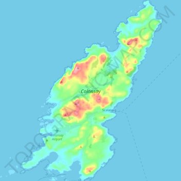
Name: Colonsay topographic map, elevation, terrain.

Location: Colonsay, Scalasaig, Argyll and Bute, Scotland, United Kingdom (56.02820 -6.27948 56.13367 -6.13312)

Average elevation: 36 ft

Minimum elevation: 0 ft

Maximum elevation: 446 ft

Other topographic maps

Click on a map to view its topography, its elevation and its terrain.

Gear up for your next adventure:

💧Water Filtration Bottles - Safely drink from streams and lakes while exploring
🪵Folding Camp Saw - Compact saw for wood and campsite work
🥩Freeze-Dried Meals - Nutritious and lightweight food for remote expeditions
🪶Camping Sleeping Pad - Comfortable sleeping pad for backpacking
🎒Trekking Poles - Sturdy poles for balance and stability on rough terrain

As an Amazon Associate, this site earns from qualifying purchases at no extra cost to you.