
Veyziat topographic map
Interactive map
Click on the map to display elevation.
About this map
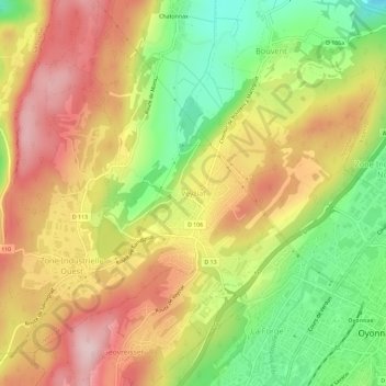
Name: Veyziat topographic map, elevation, terrain.
Average elevation: 1,969 ft
Minimum elevation: 1,512 ft
Maximum elevation: 2,379 ft
Other topographic maps
Click on a map to view its topography, its elevation and its terrain.
La Beliere
France > Auvergne-Rhône-Alpes > Ain > Oyonnax
La Beliere, Oyonnax, Nantua, Ain, Auvergne-Rhône-Alpes, France métropolitaine, 01100, France
Average elevation: 2,635 ft
Oyonnax
France > Auvergne-Rhône-Alpes > Ain > Oyonnax
Oyonnax, Nantua, Ain, Auvergne-Rhône-Alpes, France métropolitaine, 01100, France
Average elevation: 2,503 ft